
Class 9 Social Science Understanding Society India and Beyond Part 1
Textbook Questions and Activities
Chapter Questions and Answers
1. What are the sources of energy that are required to cause movements associated with the internal forces of the Earth?
Answer:- Heat from the Earth’s core acts as the source of energy, causing molten material in the mantle to rise while cooler material sinks. This continuous movement creates convection currents that push and pull the tectonic plates, driving the internal forces of the Earth.
2. Relate various physiographic divisions you have studied in the earlier grades with various endogenic forces responsible for their origin.
Answer:- Fold mountains, such as the Himalaya, are formed by convergent boundaries where two continental tectonic plates move towards each other and collide. Mid-ocean ridges are formed at divergent boundaries where plates move apart and magma rises to create new crust.
3. Why and where do earthquakes occur frequently? Is it possible to predict earthquakes?
Answer:- Earthquakes occur frequently at plate boundaries where tectonic plates interact, especially around the Pacific Ocean, which is known as the Ring of Fire. They happen when oceanic plates sink beneath continental plates or when plates slide past each other at transform boundaries. While modern science cannot predict the exact timing of earthquakes, ancient texts like the Brihatsamhitā show early attempts to predict them by observing changes in animal behavior, wind, and clouds.
4. “Plate movements are responsible for the distribution of earthquakes and volcanoes.” Explain. Answer:- The outermost layer of the Earth is broken into tectonic plates that constantly move over a semi-molten layer. Most earthquakes and volcanoes occur directly along the edges where these plates meet, known as plate boundaries. For example, when an oceanic plate collides with and sinks beneath a continental plate, it causes both volcanic activity and earthquakes.
5. Draw and label a diagram of a meander and a delta.
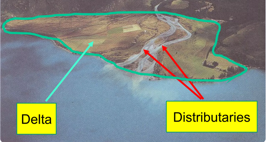
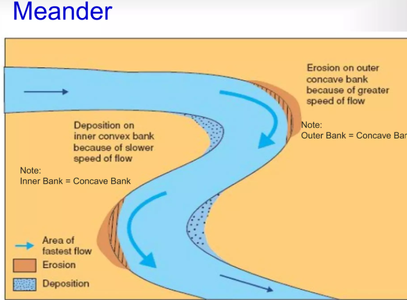
- Meander: Draw a winding river curve and label the Oxbow lake, the Steep Bank on the outer edge, the River flowing through, and the Bar on the inner bank where deposition occurs.
- Delta: Draw a fan-shaped landmass at the river’s mouth and label the main River, the smaller Distributary channels, the Islands/Bars formed by sediment, and the Sea.
6. How are deforestation and erosion associated with each other? Explain.
Answer:- Deforestation removes the vegetation cover that protects the land. Without plant roots to hold the soil together, the land is exposed and becomes loose and dry. This makes it much easier for strong winds to pick up fine particles, leading to wind erosion and dust storms. It also increases the instability of slopes, contributing to severe landslides during heavy rainfall.
7. Develop a plan to protect the land in your local area from erosion.
Answer:- To protect local land from erosion, you can implement traditional water and soil management techniques. You can construct continuous contour trenches (CCT) and earthen embankments along hillsides to slow down rainwater and prevent soil from washing away. Building check dams across small streams will reduce water velocity and allow sediments to settle. Finally, planting more trees will help hold the soil together securely.
8. Which disasters do you think you might experience in your region? Discuss a mitigation plan in your classroom.
Answer:-
- Mountainous regions: May experience landslides, avalanches, or Glacial Lake Outburst Floods (GLOFs). Mitigation includes avoiding construction near steep slopes or drainage paths and maintaining clean drains.
- Arid/Desert regions: May experience dust storms. Mitigation includes planting vegetation and avoiding overgrazing to keep soil bound.
9. Prepare a model of landforms created by underground water.
Answer:-
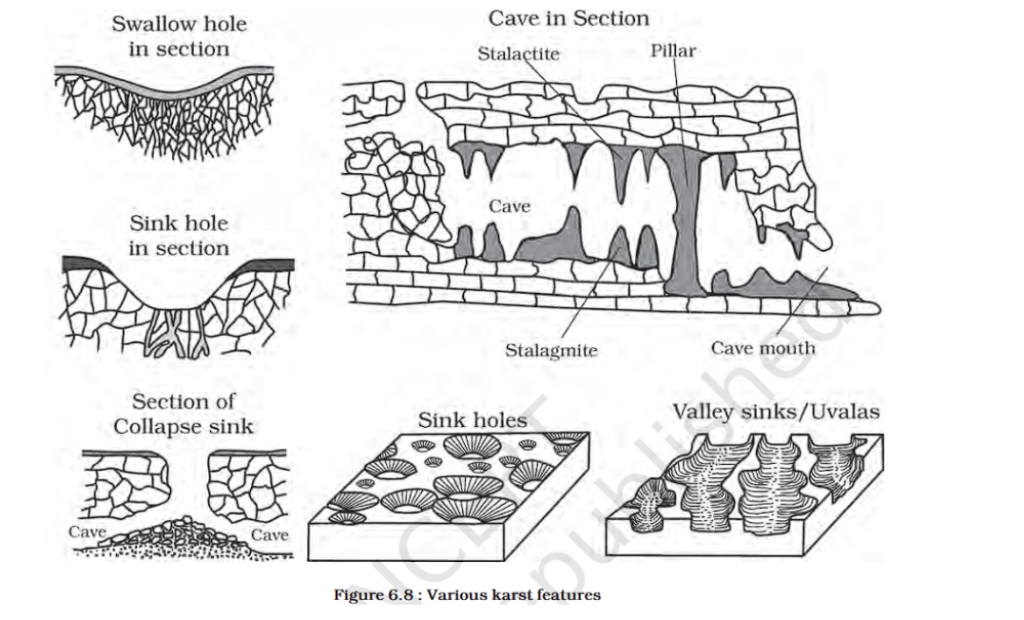
To create your model of Karst topography, you should include features formed when acidic water dissolves rocks like limestone. Your model should feature hollow caves, icicle-shaped stalactites hanging from the ceiling, stalagmites rising from the floor, and surface depressions called sinkholes.
10. What precautionary measures will you take if you are staying in an earthquake-prone region? Answer:- You should watch for early warning signs like subsidence of buildings or unusual sounds such as cracking trees. During an event, stay calm, do not panic, and stay together with your companions. Move away from downstream valleys or dangerous paths quickly and do not touch loose electrical wires or poles after the event.
Guidelines for Classroom Activities (Questions 11-15)
- 11. Prepare a Map: Use an atlas to identify regions around the Pacific “Ring of Fire” (for earthquakes/volcanoes) or mountainous regions like the Himalayas (for avalanches/landslides) and mark recent events from this calendar year.
- 12. Create a Poster: Choose a local landform (like a specific river, delta, or mountain pass) and illustrate it. Research local folklore or cultural significance to add to your poster.
- 13. Document a Case: Research a historical disaster in your region. For example, you could document the devastating floods in the Chamoli district of Uttarakhand in February 2021, highlighting the damage to buildings, livestock, and hydel projects.
- 14. Translate Poster: Use the “Before, During, and After” landslide instructions provided at the end of the chapter and rewrite them in your native language. Display this translated list at home.
- 15. Group Project:
- Water Group: Focus on river landforms (V-shaped valleys, waterfalls, deltas) and disasters like floods.
- Wind Group: Focus on desert landforms (yardangs, dunes) and disasters like dust storms caused by loose soil and strong winds.
- Glacier Group: Focus on glacial landforms (U-shaped valleys, moraines) and disasters like GLOFs and avalanches.